Fall & Winter Escapes
Save 10% on your bareboat sailing or skippered charters departing between now and March 31, 2027*! Book by June 29, 2026.

Sailing Experience
At least 20 days or 400 miles as skipper on an equivalent size yacht
When it comes to your vacation, only the best will do. Speak with a Vacation Planner to begin your journey towards your next exceptional charter escape.
“I wanted to take a moment to formally thank you and your team following our recent charter. Our experience at the Belize base was exceptional in every respect. This was our first charter with The Moorings—and it certainly will not be our last.
From the moment we arrived until departure, every detail was handled with remarkable care and professionalism. The warmth, attentiveness, and genuine hospitality shown by your staff did not go unnoticed. The entire operation was seamless and welcoming.
Please extend my thanks to everyone on your team. We look forward to returning in the future and sailing with The Moorings again…”
John M. – Belize Charter Guest, 2026
Save 10% on your bareboat sailing or skippered charters departing between now and March 31, 2027*! Book by June 29, 2026.

We are driven to deliver amazing sailing experiences for you and your crew at the best possible price.
20+ Destinations worldwide
customer reviews
rewards program & discounts
award winning yachts


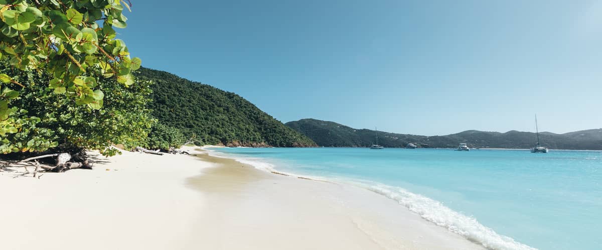
We offer Belize yacht charter itineraries that showcase the very best of this Caribbean paradise. With the perfect balance of relaxing and exploring, you might be immersing yourself in local culture one moment and uncovering the treasures of a secluded beach the next.
Take a look at our Belize yacht charter itineraries and start planning the kind of trip you’ll remember for a long time.

Discover the beauty of southern Belize on a 7-day Placencia sailing charter. With the flexibility of a bareboat itinerary, you’ll island-hop through pristine cayes, vibrant reefs, and laid-back coastal villages, setting your own pace as you explore one of the Caribbean’s most unspoiled cruising grounds.

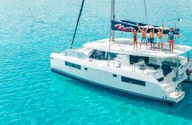
Explore the coastal wonders of Belize on a crewed charter vacation. Since some areas in Belize’s cruising grounds are off-limits to bareboat charters, a crewed yacht itinerary allows you to visit destinations that aren’t accessible otherwise.
A spectacular 14-day Belize sailing itinerary exploring vibrant islands, remote cayes and the breathtaking Belize Barrier Reef from Placencia to Ambergris Caye and beyond.
As you start planning your Belize yacht charter, you might be wondering which of our world-class charter types to book. We understand that everyone is unique and has different requirements, and we don’t believe that you should settle for anything less than your dream vacation.
We offer a selection of yacht charters in Belize to cater to your preferred style of cruising. Opt for the independence of a bareboat charter, the convenience of a skippered vacation, or the comprehensive care of an all-inclusive crewed charter.
You have the freedom to choose whichever Belize yacht charter suits you best…so which one can you picture yourself setting sail on?
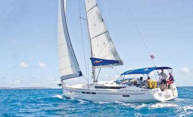
A bareboat sailing charter allows the opportunity to charter a yacht yourself whilst delivering a private yacht experience on the water.

A luxury crewed yacht charter delivers the ultimate all-inclusive vacation on the water aboard your own private sail yacht or power catamaran.
Our Belize yacht charter fleet is a collection of state-of-the-art yachts, each promising a smooth and memorable sailing experience. Choose from a selection of our sleek catamarans, ideal for group voyages among the cays, and perfect for an intimate exploration of Belize’s hidden inlets.

View our fleet of innovative and stable sailing catamarans.
View our fleet of comfortable, performance monohulls.
The Moorings is honored to receive recognition for its fleet and vacation planning services. Awards include TripAdvisor Traveler’s Choice Awards 2025, 2024 and 2023, and The British Yachting Awards 2023.


The cost of chartering a yacht in Belize ranges from a starting price of $3,144-$29,249*, based on a 7 day charter for 2 people. Your Belize charter price will differ, depending on a number of factors, such as duration, time of year, number of passengers, itinerary, yacht type and charter type.
Season and charter type are two of the most impactful factors when calculating the cost of a Belize yacht charter. The following costs are based on a 7 day Belize charter for 2 people:
| Charter Type Season | Starting Price: Low | Starting Price: High Season |
| Belize Bareboat Charter | $3,144 | $15,999 |
| Adding a Skipper to a Bareboat Charter | $190 per night | $190 per night |
| Belize Crewed Charter | $14,449 | $29,249 |
*Please note that all pricing is subject to change and is based on information available at the time of publication. This was last updated in April 2026. To work out the full cost of your Belize sailing vacation, build a bespoke quote today.
Mooring fees in Belize are generally low, with typical costs ranging from around $15-$25 per night for mooring buoys, plus a $10 per person, per day marine park fee in protected areas*.
For example, the Pelican Cayes near Hideaway Caye, moorings cost around $20 per night. At Ray Caye, mooring balls outside the channel cost around $15 per night, while those inside the channel are around $25 per night. Docking is also available, costing approximately $29 per night for yachts up to 50ft, and around $3 per foot, per night for larger vessels.
*Please note that all pricing is subject to change and is based on information available at the time of publication. This was last updated in April 2026.
Additional costs you will need to consider when planning a yacht charter in Belize include: Flights (around $350-$800 pp for a round-trip, and usually includes Departure Tax), taxi transfers, taxes and customs fees, fuel (a full tank is included for all sailing charters), mooring fees (approx. $15-$25 per day), provisioning (around $50-$75 pp, per day), Yacht Damage Waiver ($80-$170 per day), optional charter extras, and gratuity.
For 2 people on a 7 day yacht charter in Belize, additional costs can start from around $1,200*. To account for living and operational costs, you should aim to factor an additional 25-50% of the initial charter price into your overall budget.
*Please note that all pricing is subject to change and is based on information available at the time of publication. This was last updated in April 2026. To learn more, take a look at our Belize Useful Information Page.
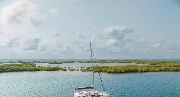
If you follow one of our Belize sailing itineraries, you will sail to the beautiful Whipray Caye to soak up the sun and enjoy some of the best fishing in the whole of the Caribbean and Americas, before heading to Lagoon Caye, Lark Caye and South Water Caye.
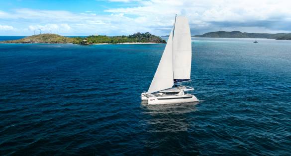
You can rest assured that, no matter what route you take on your Belize sailing vacation, balmy trade winds blow steadily and sure, promising exquisite cruising as you explore the less traveled charter grounds behind Belize’s barrier reef system.
With so many incredible islands and cays to explore, it couldn’t be easier to sail around Belize and uncover each of their treasures. Whether you’re taking the helm on a 7-day Belize bare boat yacht charter, or treating yourself to an all-inclusive crewed charter, you’ll be able to spend your days cruising the open waters and discovering new islands every day.
We think a 7-day boat charter in Belize is ideal because it gives you the perfect amount of time to immerse yourself into the Belizean culture, explore beautiful islands, unleash your inner adventurer and go scuba diving, visit the hidden gems of Belize, and also relax on the deck with a cocktail in hand.
However, you have the freedom to choose the length of your sailing vacation, just like with all our Moorings yacht charters in destinations such as the Mediterranean, Caribbean and Exotics.
Note: Due to Belize fishing laws, charterers who are interested in fishing for leisure or sport must hold a sport fishing license. The fees are US $25 per week. You may purchase these licenses at our Belize charter base. Spear fishing guns are legal only when free-diving and no tanks are allowed when using spear guns. The lobster closed season runs from midnight February 14 to midnight June 15.
Belize is subtropical, with a mean annual temperature of 80°F (27°C )., making it the ideal location for a relaxing yacht charter. Trade winds blow along the coast and on the cayes most of the year, keeping temperatures pleasant even in the hottest months, except for a few weeks, generally around mid-August through mid-September. During the height of Summer, temperatures can reach the mid-90s (around 35°C) on the mainland.
You may find that Winter storms bring the temperature down to the low 60s (16 to 18°C). You will find that the rainfall is heaviest in the south and the jungle areas, lightest in the north and on the cays. The dry season generally lasts from December to May; the rainy season is typically June to November. Hurricanes occur occasionally; they are most likely to hit in August and September.
During your Belize sailing vacation, you can also enjoy water temperatures of between 79°F to 83°F (26°C to 28°C), a delightful temperature for snorkeling around the Belize Barrier Reef. Waves inside the barrier reef are minimal but the breeze is fresh creating superb sailing conditions. Outside the barrier reef in the blue water Turneffe Islands and Glover’s atolls are each a half day’s sail away and Lighthouse Reef can be reached in another half day sail.
Weather forecast
The base provides a weather forecast for the first day and will provide a listing of stations that broadcast weather. Immediate weather conditions can be found at https://www.weather.com.
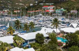
Whether this is your fifth trip or the first of many, we want you to feel at home when you’re at a Moorings base. At Laru Beya Marina, we welcome you to relax at the resort before boarding and setting sail from Placencia.
If you’re wondering when to book your Belize yacht charter for, the dry season generally lasts from December to May and the rainy season is typically June-November. Hurricanes occasionally occur and are most likely to hit in August and September.
As the sailing season in Belize runs from November-April, it is the perfect destination for a Winter getaway, much like the BVI, Antigua and St Thomas. For alternative winter sun sailing destinations, explore our Where to sail in December guide.
As you embark on your Belize yacht charter, you’ll notice that the tide range is very small at around 11 inches – 23 inches, including the variation of level due to atmospheric pressure and dominant winds.
The waves inside the barrier reef are minimal but, the breeze is fresh, creating superb sailing conditions.
If you’ve been to the BVI in the Caribbean, or a Mediterranean hot spot like Greece or Italy, and found that the tidal range was ideal for you, you’ll love a sailing vacation in Belize as they all have very similar tidal ranges.
Want to learn more about the impressive sailing conditions in Belize? Contact us today and one of our team will be happy to answer any questions you have.
Start your experience with The Moorings on land and sign up to receive e-mails from us about yachts, offers and destinations.
By clicking 'Sign up' you confirm that you have read and understood our Privacy Policy and consent to our use of your information.